Every seismic microzonation project in Darwin starts with the same observation: the subsurface here is far more variable than a regional hazard map can capture. You have deep Cretaceous siltstones in the city centre, pockets of dense laterite around Marrara, and up to 15 metres of loose estuarine clays along the Ludmilla and Rapid Creek floodplains. The 2012 Thamarrurr swarm reminded the Top End that earthquakes do happen, and AS 1170.4-2007 demands site-specific data for structures over 12 metres or Importance Level 3 and above. We combine downhole seismic testing with MASW to build a Vs30 profile that holds up under peer review, and we correlate it with CPT logs to resolve transitions between soft clay and stiff residual soils. That is the difference between a generic site class D and a defensible site class C — and it changes your base shear calculation.
A Darwin site class map is only as good as the Vs30 measurements behind it — we never interpolate across a geological boundary without a ground truth point.
Technical details of the service in Darwin
Risks and considerations in Darwin
The most expensive mistake we see in Darwin seismic microzonation is using default site class assumptions without ground investigation. A developer assumes the flat block in Berrimah is class C because the borelog says 'stiff clay' at 2 metres — but the Vs30 measurement comes back at 195 m/s, putting it firmly in class D. Suddenly the seismic base shear jumps 30% and the structural frame needs re-engineering. Another common error is mapping liquefaction susceptibility from SPT blow counts alone, without considering the age and cementation of the deposit. Darwin's lateritic soils can produce N-values that look loose but are actually cemented, and a cyclic triaxial test tells a very different story. We run liquefaction analyses that incorporate CPT-based fines content and age correction factors from the literature, so the hazard map reflects actual cyclic resistance, not a raw blow count.
Our services
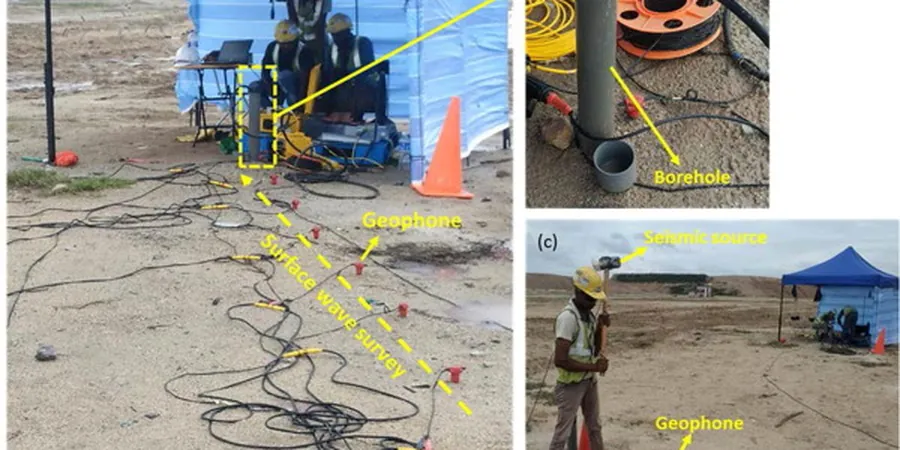
A Darwin seismic microzonation study is not a single test — it is a field campaign and a desktop analysis packaged together. The deliverables depend on the project stage and the governing authority. Below are the two core service formats we provide across the Top End.
Suburb-scale microzonation for planning authorities
We design a grid of 50 to 150 measurement points per suburb, using a combination of MASW, downhole seismic, and existing borehole data. The output is a GIS-ready site class map with amplification factors for short and long period structures. This format suits council disaster management plans and strategic land-use rezoning exercises.
Site-specific seismic hazard assessment for individual structures
For a single high-importance building — a hospital wing, an LNG plant control room, or a multi-storey residential tower — we run 1D equivalent-linear site response analysis using DEEPSOIL or Strata. The deliverable includes surface acceleration time histories, response spectra at foundation level, and a clear statement of site class per AS 1170.4. We handle the full chain from field testing to the final spectra that the structural engineer plugs into ETABS or SAP2000.
Frequently asked questions
Does Darwin really need seismic microzonation — aren't earthquakes rare here?
Earthquakes are less frequent in Darwin than in Wellington or Christchurch, but the seismic hazard is real. The 2012 Thamarrurr swarm included a magnitude 5.4 event felt in Darwin, and the AS 1170.4 hazard map assigns the city a hazard factor Z of 0.08 to 0.10. For an Importance Level 3 or 4 structure, the standard requires site-specific analysis. Ignoring it means the structural design may be non-compliant, and the certifier will flag it.
What is the typical cost range for a seismic microzonation study in Darwin?
The cost depends on the number of measurement points and the size of the area. For a typical Darwin project, the range is between AU$6,540 for a targeted site-specific assessment with a few measurement points, and up to AU$23,030 for a suburb-scale microzonation with dense grid coverage and full GIS deliverables. We provide a fixed-price proposal after reviewing the site plan and the required mapping resolution.
How long does a microzonation study take from fieldwork to final maps?
Fieldwork for a typical 20-point grid takes three to five days on site. Processing, 1D modelling, and map production add another two to three weeks. If the project requires a peer review or a council pre-lodgement meeting, we budget an extra week. Rush turnaround is possible during the dry season when field crews are available.
What is the difference between a microzonation map and a site class from a single borehole?
A single borehole gives one site class at one location. A microzonation map interpolates between multiple measurement points to show how site class and amplification change across a site or suburb. For a large industrial site in Darwin where soil conditions change from laterite to soft clay over 200 metres, the map reveals transitions that a single point misses. The structural engineer uses the map to place each building pad on the right ground, rather than designing the whole site for the worst case.